Multibeam Echosounder Survey Helps Protect Transportation Infrastructure
Route 16 is a state highway that extends from Portsmouth, New Hampshire on the Atlantic coast to the northern part of the state where Bear Brook runs adjacent to the highway. The river is causing erosion along Route 16 near Errol, New Hampshire. The New Hampshire Department of Transportation (NHDOT) constructed an engineered log jam to divert the river’s flow and halt the damaging effects of erosion on the road.
Multibeam Survey with Modernized Mapping Helps Reduce Erosion of Critical Transportation Infrastructure
To successfully design this diversion and model river hydraulics, NHDOT needed to understand the river’s bathymetry. Collecting this river depth data enabled the transportation department to predictively understand erosive forces, model the river’s flow, and optimize a diversion structure that reduces erosion.
To conduct scientific studies of the river flow and bank erosion, NHDOT turned to the University of New Hampshire (UNH) Civil and Environmental Engineering Department in collaboration with the Center for Coastal and Ocean Mapping (CCOM), a national centre of expertise in ocean mapping and hydrography. Researchers with CCOM designed and built a multibeam-equipped mapping vessel that produces repeatable bathymetry under a variety of hazardous conditions. Selected initially for its navigation capabilities, HYPACK® software collected all sensor data streams during this effort, and CCOM quickly realized additional benefits from using this software package.
“The volume and accuracy of the data combined with the fast collection and processing times revolutionizes stream restoration efforts.” Dr. Thomas Ballestero, Associate Professor of Civil and Environmental Engineering, UNH
The Challenge of the Survey
Challenge As CCOM started its bathymetric survey of Bear Brook, obtaining accurate coordinates proved challenging. Historically, CCOM followed navigation lines designed and loaded into its navigation software ahead of each survey. This approach helps ensure proper overlap of the Multibeam swath width with the expected depth. The disadvantage is that CCOM must strictly follow each navigation line to avoid gaps in bathymetry data. While this is easy in open waterways, the small, winding Bear Brook with its frequent depth changes challenged this approach.
The Solution
Once in the field, CCOM realized its coordinates were about three kilometres (1.86 miles) off the target location, making its mapping line plans useless. However, using the HYPACK interface, CCOM was able to correct the coordinates and reconfigure the line plan in the field by driving their vessel, a Zego sports boat obtained from Higgs Hydrographic to the project boundaries and marking targets on the map. The researchers stayed on schedule and completed the mapping of Bear Brook over two days in early July 2019 and again in June 2020. The intent of the surveys was to document before and after bathymetric conditions resulting from the log jam construction.
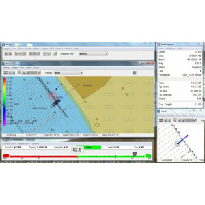
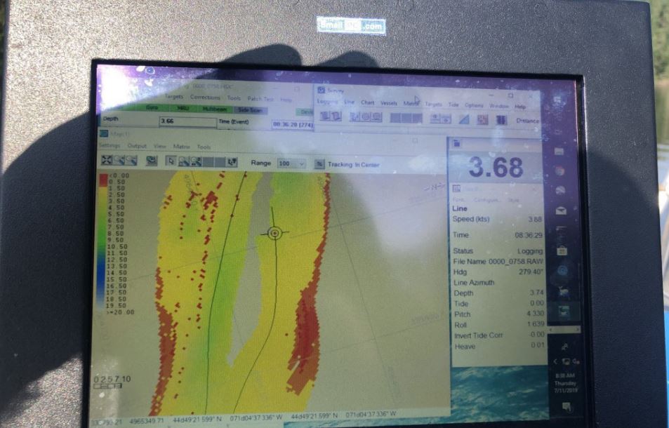
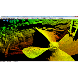
Ultimately, CCOM researchers found that using an HYPACK matrix to track mapping coverage, rather than following planned sounding lines, was a major benefit. This enabled the research team to focus on piloting the vessel in a challenging environment while tracking realtime data from the Imagenex DeltaT Multibeam sonar. The pilot’s main responsibility is to safely navigate the region. HYPACK’s simple, flexible display windows and display clarity enable pilots to easily interact with the data screen, change lines, and monitor the data streams, which is invaluable to their success. HYPACK integrates Multibeam (Delta T) and Inertial Measurement Unit (POS-MV) data, creates a map in real-time, and plots the bathymetry on screen. This enables the pilot to fill in any gaps in bathymetric coverage. HYPACK also reads the Singlebeam Odom Echotrac data stream and displays its depth along with the nadir Multibeam ping on the screen for quick assessment by the pilot. Recorded data is archived once the fieldwork is complete for the day. The raw Multibeam and Inertial Measurement Unit data require post-processing with differential GPS positioning determined with a nearby base station.
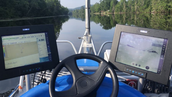
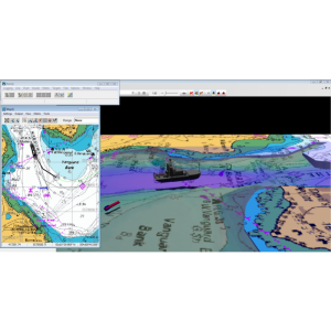
HYPACK Multibeam Software completing a survey remotely on a Zego Boat.
“While on survey, the greatest success of my HYPACK experience is seeing the monitor switch to sleep mode because I haven’t had to fuss with it.” Jonathan Hunt, Research Technician, Center for Coastal and Ocean Mapping
Outcome
CCOM found that the bathymetry detected by the Multibeam survey of Bear Brook was unique, revealing large depth drops and uneven topography owing to underwater boulders and trees. The Zego sports boat served as an ideal mapping vessel for Bear Brook because its dual pontoon design provided stability and versatility while its small size made it easy to transport and deploy at the project site.
HYPACK provided planned survey lines for the Zego boat to follow during the operations. Line spacing was set to three meters to ensure as much overlap as possible in shallow regions while still allowing the project to proceed within a reasonable amount of time. The bathymetry map developed by CCOM will aid in modelling efforts and empower NHDOT to better predict shear stresses and current flows in Bear Brook. Ultimately, this information supported NHDOT in optimizing the log jam to prevent erosion of Route 16, directly benefiting the local community and environment.
By modernizing its data collection approach with HYPACK, CCOM mapped Bear Brook more efficiently and easily than would have been possible using conventional approaches. CCOM was able to overcome a major navigational challenge in the field to deliver bathymetric data that protects critical New Hampshire transportation infrastructure.
Do you have questions about this case study?
Get in touch with HYPACK, A Xylem Brand, and they would be happy to answer any questions you have about pricing, suitability, availability, specs, etc.

![3月21日-封面[1].jpg](https://cdn.geo-matching.com/voeE1ywo.jpg?w=320&s=6b3b1a0215d770f8797653e9202a8f52)


