Mobile Mapper makes fast Data Collection Possible
In order to meet a growing demand to bring broadband and fiber optic network service to businesses and residents in the Phoenix area, BPG Designs has opted to augment its survey effort with mobile mapping via a Topcon LiDAR scanner to streamline the initial facet of its design process.
Mobile Mapper makes fast Data Collection Possible
Doing so has netted the survey, design, CAD and consulting services company some truly impressive results, including one in which a long-term project’s expected duration has already been reduced by at least three years. A great rule of thumb: when you’re measuring production savings in years, you’ve found a solution that works.
Evolution causes changes
The typical BPG project can differ greatly, ranging from something as simple as utility work being performed in a pit, to designing cable runs that can stretch up to 90 miles. Similarly, the company offers its clients a robust package of capabilities, offering everything from a detailed map of the proposed project to construction infrastructure work itself.
“We are a design-build company in every sense of the word,” said Ben Goddard, the company’s founder and president/CEO. “Part of our appeal to a potential client is the fact that we can literally take a project from square one in project management, through data collection, into planning, and on to actual construction. A good deal of our success to date is because of how robust our capabilities are.”
"Even working ten-hour days, that’s 110 days of survey versus four days using the Topcon mobile mapping solution."
- Manager of BPG’s mapping department, Nik Smilovsky
Mapping is less effort
Diverse though their workload might be, virtually every BPG project starts with a mapping effort and it was an improvement in this area — and the fact that the bulk of their work was trending towards telecom — that drove Goddard in 2014 to begin looking toward a LiDAR-based mobile mapping solution.
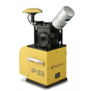
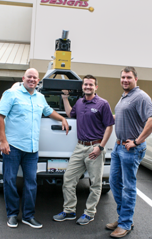
“We needed a way to gather huge amounts of data quickly — one of the main selling points of LiDAR scanning technology,” he said. “We were looking for a way to cut down the time frame on deliverables to our customers and felt that adding a mobile mapping capability could help tremendously in that regard. We first purchased a Topcon IP-S2 — which we still use regularly — but recently added the smaller, lighter, more powerful IP-S3 to our lineup. The technology proved to be a perfect fit.”
Case in point: the massive fiber-to-home effort. According to Nik Smilovsky, manager of BPG’s mapping department, while they’ve already been involved in the project for about two years, gathering that data the traditional way would easily have taken five years. He added that the Topcon mobile mapping system has laid the groundwork for some other truly impressive stats as well.
“In the last three years, we have driven over 14,000 miles collecting and processing LiDAR data,” he said. “From that data, we have extracted over 38,000 cable pedestals, 2,000 aerial poles, 21,000 individual businesses and more than 75,000 miles of line work. If you take those kinds of numbers and start to think in terms of what it would take from a manual survey perspective, it becomes an almost unimaginable task. In those terms alone, the mobile mapping solution has been irreplaceable.”
"While it’s only a matter of time until this technology becomes the ‘standard’ way of doing things for our industry, we always enjoy being ahead of the curve, and this definitely puts us there." - Nik Smilovsky
Collecting 75 miles of data in 2 days
Because of the variables involved, quantifying the impact a new technology or approach has on an operation is often difficult. However, in a large build BPG is doing in the Scottsdale/Paradise Valley area northeast of Phoenix, they set out to do just that and Smilovsky said the results have been head-turning.
“This particular project involves about 75 miles of design for underground work, overhead lines and businesses connections,” he said. “Using the IP-S3, two men were able to collect the entire 75-mile job in two days — that represents about 40 hours for collection. Then, using Topcon Mobile Mapping Office, the IP-S3’s proprietary software, it took one man a week to process it, bringing the total time invested to about 80 hours. To align the data, we manually shot some 735 brass-cap GPS monuments, which took one man two days, bringing the total to about 100 hours to have all the data collected, processed, and output.”
By comparison, he said, their surveyors can generally only do about 350 feet/hour. Given that pace, manually surveying that full 75 mile (396,000 foot) run, would take about 1,100 hours. “Even working ten-hour days, that’s 110 days of survey versus four days using the Topcon mobile mapping solution,” said Smilovsky. “At the outset of the project, we began delivering three miles a week of actual design to our customer. It’s tough to argue with that kind of production.”
Arc and Orbit
In order to process and deliver a product to its clients in an equally effective manner, Smilovsky said the company has invested heavily in the software side of the equation as well.
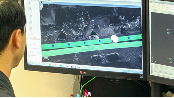
“The backbone of our data processing effort is Esri’s ArcGIS Server which, through its SQL capability, allows for the activity such as 2D analysis, creation of maps, hosting of interactive maps, and so on. To allow customers to easily extract the specific assets they need, we’ve had great results using Orbit GT. Ten years ago, a common approach to getting information to a client would have involved giving them PDFs of what we collected. Instead, capitalizing on Orbit GT’s online publishing strengths, we now create unique, interactive websites for our clients at which they can log in and see everything — the colors, the layers, the data, etc. — and download any files they need.”
He added that BPG prides itself in its ability to pick the right tool for the job, and said that having a pair of mobile mapping systems in their inventory builds on that philosophy.
“It has helped us not only meet a growing workload in this area but also expand with a satellite office just outside of San Diego. While it’s only a matter of time until this technology becomes the ‘standard’ way of doing things for our industry, we always enjoy being ahead of the curve, and this definitely puts us there.”
Do you have questions about this case study?
Get in touch with Topcon, and they would be happy to answer any questions you have about pricing, suitability, availability, specs, etc.
Related products

![3月21日-封面[1].jpg](https://cdn.geo-matching.com/voeE1ywo.jpg?w=320&s=6b3b1a0215d770f8797653e9202a8f52)


