
Mapping the Seabed in Hyperspectral Detail Using Inertial Sensor Modules
We live in the era of Big Data. This is a time when anyone can find out almost anything instantly by searching the internet. Thanks to online map applications, we can look at most places on the planet from the comfort of an armchair. To be more accurate, we can see most places on the planet’s land surface: oceans cover 71% of the planet’s surface, yet maps or survey data about marine features such as the seafloor are almost completely non-existent.
It’s true that, for navigation, sailors are well served with charts. But if detailed information is needed about a seafloor location, about its flora and fauna, or how pollutants affect the seafloor, there is today very little available.

Now planblue, a start-up company spin-off from the Max Planck Institute of Microbiology in Bremen, Germany, has taken on the mission of enabling data-rich surveys of the seafloor. Using technology innovations in underwater hyperspectral imaging, data science and artificial intelligence (AI), planblue promises to revolutionize the practice of marine surveying in two ways:
- Reducing the time required to map in detail a portion of the seafloor by as much as a factor of ten
- Cataloguing in detail the types and location of biological and waste objects on the seafloor, and rendering the data in common data formats for integration in standard software environments
As planblue says, its technology makes the invisible visible, and one component in the operation of the unique planblue underwater camera is played by an Xsens MTi-30 motion sensor.
Position-referenced Hyperspectral Imaging
The planblue technology is a combination of:
- A hyperspectral imaging system, which may be operated by any competent diver, with no special surveying or mapping skills. Future iterations of the technology will see the planblue camera mounted on a remote-control submersible, enabling data to be collected in deeper waters.
- Post-processing AI software that learns to recognize the precise spectral signatures of objects on the seafloor, distinguishing different varieties of fauna and flora, as well as identifying man-made objects such as plastic waste.
The hyperspectral images captured by the planblue camera produce data thousands of times richer than the RGB three-colour images captured by conventional underwater cameras.
And the planblue technology accelerates seafloor mapping because camera operation will be so simple and because the georeferenced images captured by the camera can be processed and tagged automatically by the AI software.

Image Credit: Tom Schils, University of Guam, USA
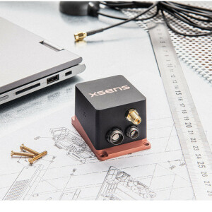
The operation of the camera is simple because the positioning and orientation of the camera unit are accurately estimated at all times. planblue’s camera unit features a device as part of its navigation system which precisely measures up to 400 times a second the camera’s acceleration in three dimensions, its rate-of-turn in three dimensions, and its orientation relative to magnetic North or South.
This device, the MTi-30 AHRS (Attitude and Heading Reference System) from Xsens, provides accurate outputs and maintains stable measurement over time and temperature thanks to proprietary calibration and compensation software implemented by Xsens.
The continuous stream of outputs from the MTi-30 enable the planblue post-processing software to tag every frame with attitude and heading information. This means that vibrations and slight tilting or inclination of the camera can be cancelled out in software, producing a map of the seafloor over the scanned surface.
The survey is also georeferenced. Underwater, the camera cannot receive satellite positioning signals. So to locate the camera precisely, each filming operation starts from a known location on the surface of the sea, acquired by reference to GPS or another satellite positioning system. By a process of dead reckoning based on the data of numerous sensors, including the Xsens inertial sensor module, along with acoustic measurements, the camera’s travel relative to this known starting point can be accurately calculated.
In any mapping or surveying operation, the accuracy of the measurements produced by the motion sensor is of the highest importance. As Nils Öhlmann, development engineer at planblue, says, the company’s decision to use the MTi-30 was driven in large part by the accuracy and stability of the sensor’s outputs. He adds, ‘The MT Software Suite which Xsens provides to developers makes it easy to integrate the sensor’s outputs into our camera system. As a start-up company, we are in a phase of rapid development and improvement of our technology. It is really helpful for us that we can implement the Xsens motion-tracking element of our camera design quickly in each new iteration of our hyperspectral camera unit.’
As awareness of the capabilities of the planblue technology grows, the company is fielding more and more requests from organizations involved in conservation, renewable energy generation, marine infrastructure development and others for detailed seafloor surveys. planblue’s success seems assured, as it works to meet the rising demand for its rapid, accurate and detailed images of the undiscovered marine environment.
For more information about planblue’s seafloor mapping technology, go to www.planblue.com.
MTi 10-Series
The MTi-30 AHRS is part of Xsens MTi 10-series. The 10-series is based on an industry-proven, cost-effective MEMS-based orientation sensor, and has an integrated, full-featured sensor fusion algorithm with easy to use SDK.
Do you have questions about this case study?
Get in touch with Movella, and they would be happy to answer any questions you have about pricing, suitability, availability, specs, etc.

Related products


