From Surveyor to National CORS Owner, How to Build Your CORS
See how a surveyor changed to the owner of this privately-run national CORS network in Uganda. With CORS, surveyors can realize easy work without setting up base stations. As for CORS owners, they can earn a profit via providing CORS service. The emerging IoT and smart city will also benefit from the wide-range high precision positioning service.
“We are proud to have taken this step and offer the benchmark level for all CORS operators in Sub-saharan Africa. We are the template for most CORS operators in Africa and continuously being sought after by many international CORS operators in Europe like Teria, Centipede, among other organizations.” – EagleCORS team
What is CORS
CORS (Continuously Operating Reference Stations) is a network, consisting of permanently installed GNSS receivers and antennas distributed in a certain area, which can transmit stable and high-accuracy RTK correction data to users. With CORS, surveyors can realize easy work without setting up base stations. As for CORS owners, they can earn a profit via providing CORS service. The emerging IoT and smart city will also benefit from the wide-range high precision positioning service.
Overview and Background
The reformation of the land sector and the development of the Land Information System increased the need to build a modern geodetic network for improved reliability and accuracy of land registration information and services. In the early 2016, no well-established and nationwide CORS serving for surveyors was completed in Uganda. David Mulindwa, a sophisticated surveyor and a loyal user of ComNav Technology products, conceived a blueprint to build a CORS that covers the entire Uganda.
“We decided to start our own CORS service because of the high demand for, quality client-centric CORS service. Often times the CORS concept from previous single CORS services wasn’t giving clients the results expected,” says David Mulindwa, CEO of EagleCORS Uganda, “A strategic plan to set up a fully functioning CORS service was laid out and our partners offered support in terms of technical knowledge, and equipment which we used to start this international level standard service.”
With strong execution and technical support, a new and well-served CORS service in Uganda, the EDAS - EagleCORS Data Access Service kick started in the late 2017. It was soon announced in full operation throughout the major cities and towns within the country at end of 2018. David Mulindwa, the CEO of EagleCORS, changed from a registered land surveyor to the owner of this privately-run national CORS network.
How to Build a CORS
1. Equipment
- 18 M300 Pro GNSS Receivers
- 18 AT500 Chock Ring Antennas
- Other hardware, including routers, lightning rods, UPS, solar panels, etc.
2. Software
- ComNav Technology CDC.NET, for VRS
- ComNav Technology CDC+, for single base
3. Project Time
From 2017 till now
4. Locations
Distributed over Uganda, including Kampala, Kiboga, Mbarara, Jinja, Hoima, Mubende, Soroti, Gulu, Entebbe, Moroto, Mbale, Luwero, Arua, Masaka, Mityana, Kamwenge, Lira, Gulu, Kisumu Eldoret etc.
5. Challenges
- Lack of experience: Having no experience in developing, running and maintaining a CORS.
- Shortage of Internet & power source: Difficult to select the appropriate internet service provider and stable and reliable power source.
- Intense ionospheric scintillation: The location of Uganda is close to the equator, suffering from more intense ionospheric scintillation and weaker signal reception.
6. Building your first station

Fig. 1 Workflow of Building the First Reference Station
Regarding the construction of entire EDAS, the first reference station is always the most exemplary and a milestone. The EagleCORS team built the first station in Kampala in late 2017. The whole work flow is illustrated in Fig. 1. Each step contributes a lot to the CORS accuracy.
“Our first station is located in Kampala, which is the major business/economic center and the Capital City of Uganda. With such important status, Kampala was critical to the start of our operations. It has always been our most treasured station since it has always played an integral role from the beginning,” explains David.
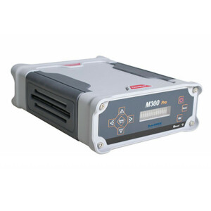
7. Select your Hardware
Hardware is vital to a CORS network. The EagleCORS team selected the most appropriate equipment - M300 Pro GNSS receiver and AT500 chock ring antenna from their partner ComNav Technology which can track all working and planned constellations and provide high-accuracy positioning and correction data.


Fig. 2&3 M300 Pro Receiver (L) and AT500 antenna(R)
In addition, routers, lightning protection device, battery protection device, enclosure AC cooling fan and other accessories also need to be prepared.
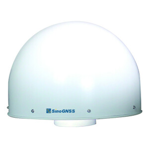
8. Identify location
A suitable location plays an important role in deciding the effect of a reference station and it often depends on the following factors:
- Coverage: The station should deliver data streams to a wide area covering Kampala and the neighboring districts within 70km radius.
- Environment: The station site should be open to the sky, far away from signal interference areas and ground objects which will cause multipath.
- Signal quality: A 24-hour signal observation should be conducted on the station site and analyzed via post-processing software (like Sinognss Compass Solution software) to check whether the satellite signal quality is good enough for a reference station.
9. Installation
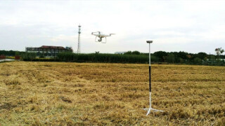
To receive good quality signals, antennas should be mounted in a most stable and unshaded place. In Kampala, antennas were professionally mounted on the rooftop of a residential house as shown in Fig. 4. Besides, lightning rods and solar panels were also installed outdoors while indoor hardware, including M300 Pro GNSS receiver, server, router, UPS and others were placed inside the enclosure-rack casing to ensure the safety, as displayed in Fig. 5.


Fig. 4&5 Antenna Mounting (L) and Indoor Hardware (R)
10. Configuration
The signal tracking status can be checked from the web page of M300 Pro or directly through the front panel display as soon as M300 Pro receiver starts to receive satellite signals. After setting the IP of M300 Pro and transmitting GNSS data to control server, the reference station was completely built.
Blueprint of EDAS
The EagleCORS team also built their own online payment systems, and has satisfied the demands of user management and data control server via CDC.NET software.
“For CDC.NET I can say we contributed to its current state. At the start it was not stable but as of today, we are one of the beneficiaries of this very good software. Very stable even on our Cloud server,” remarks David.
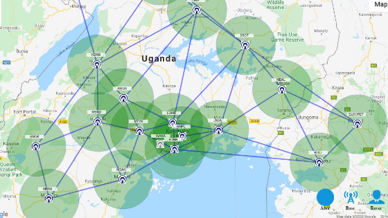
Up to now, the EDAS has built 17 reference stations in Uganda and 2 stations in east Africa (manifested in Fig. 6), covering approximately 80% of Uganda and all of these are active (19), to provide users with accurate RTCM correction data. With the rapid expansion in territory, another issue concerning baseline distance between stations arose. Thus, a reasonable planning is important to obtain better data quality against ionospheric scintillation.

Fig. 6 EDAS network 2021
“We have so far covered approximately 80% of the country although we have plans to completely cover the entire country by 2022,” plans David, “Our plan is to have 50 active station in Uganda lone and another expansion program to cover the region of East Africa as such we hope to play a leading role in contributing towards realization of Africa Geodetic Reference frame-AFREF.”
Operating a CORS
1. Daily work & Operational status
“We don’t spend so much time maintaining this project as the equipment is highly dependable and rarely does it go off,” says David.
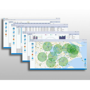
So far, EDAS has operated on track with high-automated software CDC.NET and can be effectively managed. EDAS has average 50 active users every single moment and approximately 200 - 300 users every day. Every user can be monitored and managed in real time as displayed in Fig. 7.

Fig. 7 CDC.NET Interface
2. Changes & Benefits
A mature and proven national CORS network can bring changes and benefits to both users and owner. Users in Uganda can save much money and time to get a fixed positioning solution by directly connecting to the EDAS instead of setting up base stations themselves when conducting a project.
“EDAS-EagleCORS Data access service was first started as pilot program but then we made great improvements, innovations coupled with targeted investments in terms of more stations, online payment systems, among others at which point we made it commercial.” explains David.
The EagleCORS team started to build EDAS in late 2017. It only took them one year to build EDAS to a large scale and another year to make ends meet, which means they have started making profit at the end of 2019.
Conclusion
It is well informed from the successful case from Uganda that a well-developed CORS network is constituted of professional geodetic knowledge, high-performance GNSS equipment, reasonable site planning, efficient management systems and insightful eyes, each element is indispensable.
With more and more applications of RTK survey, CORS network is becoming a common trend because it can largely save surveyors’ time and money, which is firmly proved by the successful case of EDAS. Over a long period of time, CORS build is necessary and promising.
Superior-powered GNSS equipment contributes to this success project largely. M300 Pro GNSS receiver, combining high precision GNSS module, intuitive web configuration interface, abundant data transmission and flexible connection, provides CORS administrators with highly stable and reliable user experience.
David remarks, “M300pro is one of the best Geodetic receivers we have used. Its dependable and costs reasonable price compared to other brands but most important for any CORS operator is that this receiver is very stable and comes with in built power that ensures round the clock logs in even in periods of unstable power supply.”
David Mulindwa
CEO of EagleCORS Uganda
About ComNav Technology
ComNav Technology is the major provider of GNSS OEM boards, receivers and high precision positioning solutions, encompassing product development, and marketing. Its technology and products have already been applied in a wide range of fields such as surveying, construction, machine control, agriculture, intelligent transportation, precise timing, deformation monitoring, and unmanned system. With its experienced team and innovational spirit, ComNav Technology is always trying best to provide reliable and competitive products to global customers. In 2015, ComNav Technology was listed on the China National Equities Exchange and Quotations (NEEQ), Securities: ComNav Technology (Compass Navigation), Stock code: 833972.
About SinoGNSS
SinoGNSS is the official trademark of ComNav Technology Ltd., registered in People’s Republic of China, EU, USA and Canada. All other trademarks are the property of their respective owners.
Do you have questions about this case study?
Get in touch with ComNav Technology, and they would be happy to answer any questions you have about pricing, suitability, availability, specs, etc.
Related articles


