Eye4Software Launches Latest Version of their Hydrographic Survey Package, Hydromagic
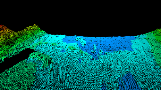
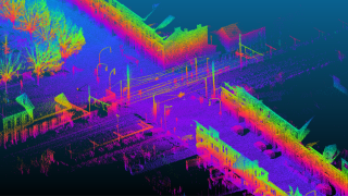
Eye4Software B.V. is proud to announce, that the latest version of their professional hydrographic survey package, Hydromagic version 10.0, has been released to the public. The main purpose of this software is to map the bottom of rivers, reservoirs, frac pits, ponds, and oceans in 3D. This is done using a connected GNSS (RTK) receiver together with a hydrographic Echosounder.
The main purpose of this software is to map the bottom of rivers, reservoirs, frac pits, ponds, and oceans in 3D. This is done using a connected GNSS (RTK) receiver together with a hydrographic Echosounder.
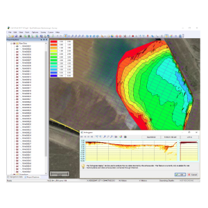
Using various post-processing options, the processed sounding data can be used to generate bathymetric maps, depth contours, XYZ data to export to other processing software, multiple types of volume reports and much more.
Our software is known to be user-friendly, easy to learn and low-cost compared to other hydrographic survey software packages around. The software is in use by dredging, mining operations and survey companies around the world.
In version 10.0, we added a lot of new functionality for USVs equipped with a Dynautics SPECTRE or ArduPilot compatible (PixHawk, Cube and others) automatic pilot. More route creation, modification, importing and exporting functions have been added to our built-in route planner.
For ArduPilot compatible autopilots it is now possible to arm motors, and change the autopilot mode from within the Hydromagic software; Thus, no longer the need to run Mission Planner in parallel.
When using the redesigned MAVLink plugin for Hydromagic, the software is now able to monitor the voltage and current drawn by your USV, and you can even set an alarm when your battery voltage drops below a user-defined threshold.
For digitizing and correcting echograms a couple of nifty tools have been added. You can now remove data above or below a line drawn in the echogram display. Also, the eraser tool has been added to the echogram digitizer tool. These new tools drastically reduce the time you will be spending correcting your data.
When you enable the NMEA0183 GST (pseudo-range measurement noise statistics) in your GNSS receiver, you will now be able to display the position error calculated by the GNSS receiver in the “Data View” display, or even set an alarm which notifies you when the error exceeds a threshold entered by the user.
For a full list of new features in this version, please refer to the release notes on our website.
For more information regarding this product, or in case you are interested in a dealership for your country, get in touch below.
Do you have questions about this product news?
Get in touch with Eye4Software, and they would be happy to answer any questions you have about pricing, suitability, availability, specs, etc.
Related products


