
Experiences With the Trimble SX10 Scanning Total Station for Building Facade Survey
The use of Terrestrial Laser Scanner (TLS) tends to become a solution in many research areas related to large scale surveying. Meanwhile, the technological advances combined with the investigation of user needs have brought to the design of innovative devices known as scanning total stations.
Such instruments merge in a unique hardware both scanning and surveying facilities. Even if their scanning rate is often reduced compared to conventional TLS, they make it possible to directly georeference laser scanning projects and to complete them with measurements of individual points of interest. The recent Trimble SX10 which was launched on the market in early October 2016 has been tested and some experiences carried out with it are reported in this paper. The analyses mainly focus on the survey of a building facade. Next to laser scanning survey, a photogrammetry campaign using an Unmanned Aerial Vehicle (UAV) has been carried out. These different datasets are used to assess the Trimble SX10 issued point clouds through a set of comparisons. Since georeferencing is possible either directly or indirectly using this device, data processed both ways are also compared to conclude about the more reliable method.
Trimble SX10 Scanning Total Station Introduction
A review of the literature of the last decades shows that Terrestrial Laser Scanners (TLS) have been extensively used in geosciences, infrastructure monitoring and change detection of natural or artificial objects, among other research topics. As expected in the works of Bohler (2006) or Grussenmeyer et al. (2008),¨ the field of heritage documentation follows the same trend and uses widely this technique today, as depicted by Stylianidis and Remondino (2016). As a matter of fact, TLS enable the accurate and fast acquisition of millions of points representing the surveyed scene. Driven by always more accurate and efficient sensor technology, as well as always deeper data processing software capabilities, laser scanning is nowadays accepted as a reliable method for accurate point cloud acquisition. Besides, investigation of TLS performances was a prominent topic of research in the last decades, so that a wide range of contributions about calibration (Lichti and Gordon, 2004), study of external parameter influences (Soudarissanane et al., 2011) but also performance analysis of devices (Hanke et al., 2006) are available.
In the field of conventional surveying, terrestrial laser scanning also sometimes becomes an alternative to total stations. Indeed, a large amount of points can be captured and the accuracy of produced data may be sufficient for some projects. However, depending on the kind of deliverables to produce, total station remains a highly used device. Besides, a total station is also required in laser scanning projects when the point clouds need to be known in a specific geodetic system, such as for example a national coordinate system. This process is known as indirect georeferencing. For those reasons, parallel to the emerging use of TLS in surveying projects, total station technology has known drastic changes. In about fifty years, the electronics have brought numerous new facilities to this kind of instrumentation, in such a way that total stations now tend to become multi-task devices composed of several built-in sensors (Scherer and Lerma, 2009).
In this context, modern total stations offering scanning facilities are nowadays marketed. Most of them only offer a low scanning rate compared to conventional TLS, given that pre-defined scanning modules like line or grid scanning are provided. These simple scanning functions reach a scanning rate lower than 20 points per second, which is also mainly due to the mass of the telescope reducing the rotating velocity of the hardware. Evgenikou and Georgopoulos (2015) relate on experiences of small artifact reconstruction with a Topcon IS Imaging Station, and the presented results illustrate the low point density which is reached while using such a combined device. The recent Trimble SX10 scanning total station launched on the market in early October 2016 offers a significant improvement in terms of scanning rate. With the capability of acquiring about 26,600 points a second, it can be described as a survey instrument merging high-speed 3D scanning and total station facilities.
Provided that some reference points are known, laser scanning projects performed using Trimble SX10 can be directly georeferenced. This may be of interest for the survey of building facades, once the produced models are intended for integration in a 3D city model for example. Georeferencing approaches are described in Reshetyuk (2009) and their respective benefits and drawbacks are mentioned. Regarding the final accuracy of georeferenced data, Lichti and Gordon (2004) report on the error budget related to direct georeferencing. Furthermore, it is also assumed in Reshetyuk (2009) that direct georeferencing may be rather adapted for outdoor surveys with large spatial extent. Given that both georeferencing methods are achievable with the Trimble SX10, a first aim of this paper is to compare both approaches using the case study of a church facade survey. The same dataset was also captured using various devices and techniques, which are firstly presented. Comparisons between these different datasets are then established in a dedicated section in order to assess the precision of the Trimble SX10 issued point clouds.
Total Stations and/or Terrestrial Laser Scanners
Aim of this paper is to assess the geometrical accuracy of point clouds acquired using Trimble SX10 scanning module. For this purpose, similar acquisitions have been carried out with a second TLS in order to produce a reference dataset.
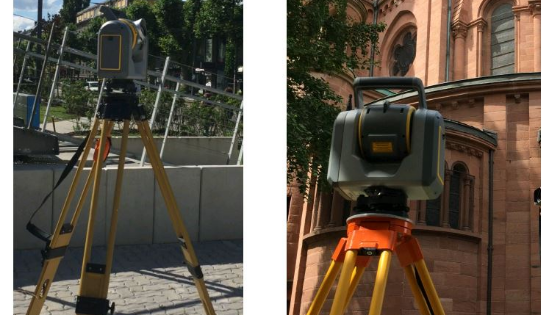
Trimble SX10 scanning total station is a recent device intended for use in laser scanning projects as well as for survey of individual points of interest. All the conventional coordinate geometry (COGO) computations available in total stations are present within this instrument. This means that Trimble SX10 can be set up and centered on a known point, and oriented on references. While preparing a laser scanning project, the captured point clouds can thus be directly known in the reference system, provided that some survey points are available in the project area. This operation is known as direct georeferencing. Trimble SX10 has been designed to allow the user to carry out only one unique device in the field, which is one of its major advantages. As a matter of fact, a laser scanning project can easily be completed thanks to the measurements of individual points of interest using the total station facilities.

Figure 1. (a) Trimble SX10 scanning total station placed on a tripod and centered on a reference point. (b) View of the rear side of the device.
Next to the combination of geodetic survey and scanning facilities, several cameras used for various purposes are mounted on Trimble SX10 device. The absence of telescope on the hardware mainly contributes to its originality. As a matter of fact, optical sighting is no more foreseen and this operation is replaced by the use of the on-board camera system. Thus the hardware is remotely steered thanks to a tablet connected to the device, since no screen is present on the hardware. This specificity is visible in Figure 1b showing the rear side of the device. Three cameras with different fields of view are available, providing three different zoom levels for aiming at a point. The overview camera is first applied for progressive zoom in, then the primary camera and finally the telescope camera, which offers the greater magnification. For point cloud colorization, the user can choose between the two first cameras and the overlap between pictures can be selected. These cameras are also useful for the creation of panoramas or for the documentation of the project, such as the documentation of reference point location for example. Compared to a conventional camera, this imaging system makes it possible to geolocalize the acquired panoramas and images, provided that the instrument has been set up on a known point. Moreover, centering the device is also achieved using a fourth camera known as plummet camera.
Trimble TX8 is the terrestrial laser scanner which has been used in order to acquire a reference dataset for the following data comparisons. Based on the same time-of-flight measurement technology as Trimble SX10 scanning module, some main technical specifications of both laser scanning systems are presented in Table 1, whereas SX10 is also a total station and imaging system.

2.2 UAV photogrammetry
The Unmanned Aerial Vehicle (UAV) employed to perform picture acquisitions on this facade is the Albris from Sensefly company, which has been initially designed for close range inspection. The imaging sensor has a resolution of 7152×5368 pixels for a sensor size of 10×7.5 mm, and the lens has a focal length of 8 mm. Due to these specifications, a Ground Sampling Distance (GSD) of 0.9 mm at 5 meters is achievable.
Read the complete articles here!
Do you have questions about this article?
Get in touch with Trimble, Inc., and they would be happy to answer any questions you have about pricing, suitability, availability, specs, etc.

More articles


