


Case Study: Ordnance Survey Cut Costs and Improve Efficiency by Creating an Affordable Mobile Mapping System With Oxts Navigation Solutions on Board
The national mapping agency for Great Britain, Ordnance Survey, was in need of a quicker and more cost-effective way of collecting georeferenced point cloud data. Read the case study to find out how by engaging with OxTS, Ordnance Survey was able to create highly accurate point clouds and reduce costs whilst simultaneously improving the efficiency of their mobile mapping operations.
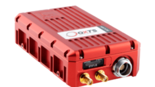
Ordnance Survey is an experienced user of mobile mapping technology. They have in the past used expensive high-grade technology to create accurate, georeferenced point-cloud maps. Whilst this method works, using high-grade, expensive systems for a long-term data collection programme isn’t manageable or sustainable. They required a lower-cost set-up that was simple to use, and could easily scale. The new system needed to enable the Ordnance Survey team to reliably create accurately georeferenced point clouds that could be used for feature identification and classification. Read the case study and learn more about how by developing a cost-effective mobile mapping system with OxTS Ordnance Survey were able to reduce costs and improve the efficiency of their mobile mapping operation.
Do you have questions about this case study?
Get in touch with Oxford Technical Solutions - OxTS, and they would be happy to answer any questions you have about pricing, suitability, availability, specs, etc.


