
American Military Cemeteries Digitized for a Solemn Mission
The Army Geospatial Center (AGC) has applied innovation to help American Military cemetery visitors find their loved ones. Traditional GPS survey methods and 3D mapping digitalization were integrated and mounted to a backpack specially built for the collection portion of this project. A web interface that acts as the front end for the collected data provides a straightforward interface for visitors to find their relatives and access amplified information stored in the GIS database.
A Pilot Project for a Solemn Mission
Finding a particular headstone in an American National Cemetery often requires extensive and time consuming records reviews by administrators. To help visitors easily find their loved ones, the Army Geospatial Center (AGC) in collaboration with the Arlington National Cemetery (ANC) has completed a pilot project including the Corozal (Panama) and Normandy (France) Cemeteries which, when combined, consist of more than 15,000 gravesites.
This massive project combines traditional surveying methods and modern technologies to create virtual models of both cemeteries. The models include not only the underlying terrain and GPS coordinates for each headstone or memorial, but also features like roads, sidewalks, trees, curbs, gutters, monuments and many other man-made structures with an estimated accuracy of 10 cm (3.9 inches). Geo-located photographs of the front and back of each headstone to aid in identification completed the collection solution.
The collected data was processed and integrated on the ENFIRE laptop. Thanks to these innovations, visitors can access cemetery data, search for loved ones or find historically significant gravesites by using the kiosks at the facilities that are running the ANC Explorer program. Virtual visitors have identical functionality using the program on their home computer or mobile device.

American Cemetery in Normandy
Backpack-based Mobile Mapping Method
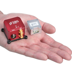
In order to map the cemeteries in their entirety with maximum details, Matthew R. Staley, Military Engineering and Survey Support Scientist at the US Army Geospatial Center, developed a backpack-based mobile mapping solution. Employment of the equipment minimizes cost by decreasing collection times and by providing data in formats that are easy to manage. It leverages tools used by the U.S. Military Survey Services called ENFIRE and GPS-S. “I coupled a LiDAR from Velodyne with the Ellipse2-D Inertial Navigation System (INS) with embedded RTK GPS from SBG Systems” explains Matthew R. Staley. He chose the Ellipse2-D because of its all-in-one GNSS and Inertial solution packaged in a compact and low-power consumption device. The INS/GNSS is used for motion compensation and for point cloud georeferencing. To achieve best accuracy a Real Time Kinematic (RTK) base station was installed in the cemetery. Hypack software was used to manage the generated point cloud.

Courtesy Photo Spc. Zachary Wright, Engineer Soldier with the 512th Engineer Detachment walks along a road in Corozal American Cemetery in Panama City 06/28/18
Adjusting the Magnetic Declination
One of the challenges was magnetometer calibration which is affected by the iron content of the location. Magnetic declination changing depends on the location; thus shipping the backpack from the U.S to France changed the magnetic declination. The American National Oceanographic and Atmospheric Agency (NOAA) updates a global map of the Earth’s magnetic field every 5 years. This map can be used, given a specific location and date, to determine the magnetic declination in that specific place. SBG Systems embeds this map into their Inertial navigation systems, enabling automatic True North heading while using magnetometers.
Surveying around Trees
Another challenge was surveying in proximity to certain tree types that greatly affect satellite reception. Mr. Staley modified the data collection procedure to compensate for this issue and is continuing research into ways that will further mitigate the vegetation to reception effect. Additionally, reducing the LiDAR range to obtain a better accuracy (+/- 5 cm overall) will be investigated as a way to mitigate yaw artifacts. “I will test the Qinertia post-processing software from SBG soon, it could help in keeping a robust accuracy in all conditions” adds the U.S. Military Engineer. Post Processing Kinematic (PPK) software such as Qinertia gives access to offline RTK corrections and enhances inertial navigation systems’ performance by post processing inertial data with raw GNSS observables using a computation called Forward-Backward-Merge. Recently released, Qinertia software has been designed to be Intuitive and easy-to-use and has been independently characterized as the fastest post-processing software on the market.

Normandy American Cemetery Mapping
What's Next?
The primary mission was to capture data related to interments and to confirm the applicability of ENFIRE, GPS-S and LiDAR toolsets to the operation and management of the Arlington National Cemetery. The ability to audit the grounds, update records, perform construction and grounds maintenance assessment from the collected LiDAR data and develop strategic plans that support increased efficiencies in their business processes was realized. Now that the pilot phase has concluded, the Army Geospatial Center is closely collaborating with Arlington National Cemetery and the American Battle Monuments Commission to assess the findings and determine a strategy for future enhancements and innovations. Initial results proved (when compared to previous efforts) that costs were minimized and an overall excellent return on investment was realized by multiple communities.
Do you have questions about this case study?
Get in touch with SBG Systems, and they would be happy to answer any questions you have about pricing, suitability, availability, specs, etc.
Related products


