Aerial Imagery from UAVs
Aerial photography taken from unmanned aircraft is the technology of the moment, with many equipment manufacturers, software developers and service suppliers getting in on the act. Richard Groom reviews the state of the technology and provides some advice for clients.
Background of UAVs Technology
Up until 2000, to map an area of more than about 50Ha the technology of choice was photogrammetry. Overlapping vertical aerial photography was taken using specially adapted light aircraft with heavy, expensive, calibrated metric cameras. This enabled photo grammetrists to build virtual 3D models. Surveyors would survey on the ground the coordinates and heights of points visible on the models, so that they could be rotated and scaled to the national coordinate reference system.
The advent of precise GPS (and latterly multi-constellation GNSS) and inertial motion sensors meant that less ground control was needed and digital photography enabled automated model generation with pixel matching software, but the technique has remained fundamentally unchanged.

Then, around the turn of the millennium, along came LiDAR as a practical alternative for producing digital ground models. This technology depended upon GPS and inertial sensors in the aircraft to determine the precise position and attitude of the plane. A laser scanner would scan the ground to produce a cloud of 3D points.
Other than the 3D coordinates, there is little intelligence that can be gleaned from a LiDAR point, but it is possible to record observations to the first, intermediate and last points that the LiDAR hits on its way down from the plane. The first return might be from the tree canopy, the second could be from a tree trunk and the third could be from the ground. Using this, and sophisticated filtering algorithms, it is possible to produce a ‘bare earth’ digital terrain model. Under ideal conditions, the height accuracy can get down to a few centimetres and at a much lower cost than photogrammetry.
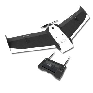
Fixed wing UAVs
In recent years fixed-wing unmanned aircraft (UA) have been developed for taking aerial photography. They can easily be carried around in the boot of a car and launched and landed from small areas of open grassland. When used for mapping, the enabling technological breakthrough is not the aircraft, but the software used to buildt he photogrammetric models.
Innovative companies have produced software that can take a bundle of overlapping consumer-grade images and produce 3D models cheaply and largely automatically. The result is that it is no longer necessary to take the photography with a heavy, calibrated camera because UAVs can carry small, massproduced high-resolution cameras, such as you might find in a mobile phone. These are light and can be carried by light aircraft – most weigh less than a kilogram.
Camera calibration is treated as an unknown by the processing software - that is solved at the same time as the 3D model is built. But to do this requires photography with 80 to 90% overlap. The process depends upon redundant image data so, given the small amount of time needed to cover an area, it makes sense to fly it twice with the second set of flight lines perpendicular to the first.
UAVs carry rudimentary GPS positioning and MEMS inertial sensors. These observations also go into the mix as a means of letting the program know roughly where each image is located before the processing begins, as well as contributing to the georeferencing of the product.
Multicopters
Muilticopter UAVs are ideal for inspection work because it is possible to control them so that they hover over the objects to be photographed. They are generally heavier than fixed-wing aircraft and can carry larger payloads. Using high-resolution cameras or video, they are regularly used for inspection work on oil rig facilities, power-line towers and other locations that may be inaccessible or dangerous. Helicopters have not generally been favoured for mapping because they have a shorter range but they do have the advantage of being able to carry a heavier payload. They can carry more sophisticated cameras and recent developments have seen helicopter UAVs carrying other sensors, such as laser scanners and hyperspectral imagers. The flight time (range) for multicopter UAVs is currently around fifteen minutes. For mapping purposes this means coverage of around ten hectares in each flight. The range will no doubt increase as the technology develops.
Because multicopters can be used for inspection work as well as mapping, they have access to a much larger market than fixed-wing UAV and it seems inevitable that they will dominate within a few years.
UAVs - A New Market
Photogrammetry from UA aerial photography does not replace raditional photogrammetry of large areas, but makes remote sensing of suitable smaller sites a practical and economic alternative (or supplement) to ground-based surveying.
Georeferencing that relies on the observations from the navigation-grade sensor on the UA will only be accurate to a metre of two in plan and worse in height. Clients should beware, because it is possible to generate photogrammetric models using navigation grade GPS data. The models will appear accurate to the untrained eye. For higher accuracy, down to around 30mm in height, the surveyor has two options.
Firstly, he can observe ground control points. These are 3D coordinated points, typically markings on a flat surface, such as parking bay lines on tarmac, but in practice it is difficult to find points on flat ground that are well defined in plan, so most surveys will be controlled using premarks. These should be of a size and colour (which should be matt) that can be easily identified on the photography. Shiny objects that cause glare tend to confuse the pixel matching process and result in blurring.
Alternatively, some UAVs now have the capability of recording camera exposure positions to high accuracy using GPS real time kinematic methods. Using the latter technique no ground control points are needed, but the surveyor should avoid the risk of system errors by proving his methodology using ground control points. UA aerial photography can be used to produce a digital surface model. This is not a bare earth model because only the objects in the image can be modelled. Unlike LiDAR, the ground level will only be recorded if it can be seen on the imagery. If the supplier is offering a bare earth model, it is worth investigating the quality of the filtering algorithms that he proposes to use.
For this reason UA photography has been very popular for surveying unvegetated surfaces such as quarries. The technique is also useful for surveying other hazardous sites, such as waste tips where there are issues with safety for surveyors working on or in gaining access to the site.
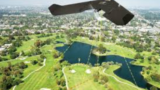
Orthoimagery is produced by draping the images over the surface model to give a single georeferenced photorealistic image. Orthoimages can be valuable for recording the surface features for record purposes and regular flights can be a useful and economic means of recording progress on development sites.
Wind
UAVs are affected by wind in two ways. Firstly if the wind is too strong the aircraft motor might not be able to gain ground when flying into the wind. Secondly, turbulence can cause blurring of the images and also result in overlaps that are either larger or smaller than planned. This effect will be less significant on larger aircraft. It is worth bearing in mind that flying is weather dependent and that contractors located close to the site will be better able to make use of good weather windows.
Wind also affects the takeoff and landing. Fixed-wing UAs land on their belly with the result that the fuselage has a limited lifespan before needing replacement. Naturally, the harder the landing the more wear and tear on the aircraft body. This can be a significant cost. This is not a problem with multicopters.
UAVs on Geo-matching.com
On Geo-matching.com you can compare 95 UAV for Mapping and 3D Modelling from 51 suppliers and view brochures, case studies and product videos. Click here to to visit the UAV category.
Related products


