
3D Laser Scanning for Virtual Reconstructions in Ancient Rome
Historical tower goes 3D, Alongside one of Rome’s most ancient roads, you can find a building that bursts with history: the Torre Salaria, a tower on the Via Salaria.
3D Laser Scanning for Virtual Reconstructions in Ancient Rome
“This road’s existence is basically documented since the 4th century B.C., but it’s a much more ancient path,” says Paola Filippini, a state archaeologist. “Its name comes from the word for salt. Via Salaria was the road where the salt trade was most prominent. It stretched from Italy’s east coast to the west coast. At the time of emperor Augustus, the city was directly connected to the Adriatic Sea by this road.”
“Via Salaria, like every Roman consular road, was accompanied by funerary monuments,” she adds, indicating the tower. “Only the Torre Salaria has remained as a testament to them. It was used a funerary monument from the 1st century onwards. The luck of this funerary monument was that it continued to be used even after the Imperial era. We know that through the 6th century it was used as a turret. It became part of a series of watchtowers and defence towers in the Middle Ages. In the 17th century, a small house was built next to the tower and used as a tavern, which it still is today.”
Distinguishing ancient forms of construction
Filippini works for the Special Superintendency of Archaeology, Fine Arts and Landscapes for the City of Rome, a dedicated organization that recently bought the tower in order to study and restore it. “We thought we could use modern techniques to create multimedia products that are not only useful for scientific purposes but also help the public to fully understand the monument.''
The Superintendency got assistance from Geores, a Roman company of specialized geologists. Co-founder and Technical Director Marco Ferrante explains how their products will support the Superintendency’s projects. “The digital models can be used for educational purposes. For example, they can be used for virtual 3D reconstructions, enriched with textual and visual content through augmented reality. It will be interesting because we will be able to distinguish the various forms of construction that have been used over the centuries.”
“With digital models, we want to help the public fully understand the monumental Torre Salaria.” - Paola Filippini, state archaeologist
Limited Time
“The main challenge is to make an extremely detailed 3D model of the external facade as well as the interior, all in a short time. This will have to be done without fitting targets directly on the monument.”
Ferrante walks us through the process. “It involves multiple phases. In the first one, we conduct a survey. The goal is to verify the logistical condition of the site. We will also identify and plan the various types of tools needed to create the 3D model. For example, laser scanners, digital photogrammetry, and UAVs for digital aerial photogrammetry. We will then deploy all these techniques to acquire the data. The last phase will take place at the office. There we will process the data and produce the various layouts we agreed with the Superintendency.”
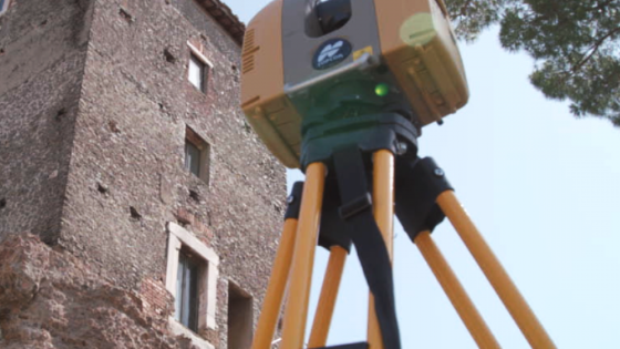
What’s happening as we speak? “Right now, we are using the laser scanner to create point clouds. In particular, we are measuring the external elevations of the building. Later, we will go inside the tower and measure the complete interior environment.”
“Combining data from these instruments, we can create accurate 3D models relatively easily.” - Marco Ferrante, co-founder of Geores
A very special tower
“The laser scanner has allowed us to increase our productivity noticeably, for both data acquisition and data processing,” says Ferrante. “Besides the laser scanner, we are also working with a photo modeling technique for this project. It generates 3D models with a high colour rendering index.”
“The GLS-2000 and the Falcon 8 complement each other perfectly. We get precisely georeferenced point clouds that we can easily integrate. We can create accurate 3D models relatively easily, in a time frame that is economically attractive.”
“The tower is a very particular tower,” says Paola Filippini. “It is notable not only because it stands out from the surrounding landscape, but also because it is partly made of basalt, the igneous rock that was used to build the Roman roads.”
This story will soon be enriched by the digital models Geores is developing. Thanks to their skilful approach, it will become easier for the Special Superintendency of Archaeology, Fine Arts and Landscapes for the City of Rome to bring the city’s past to life for a broader audience. As history goes 3D, the tower is sure to remain there for centuries to come.
Do you have questions about this case study?
Get in touch with Topcon, and they would be happy to answer any questions you have about pricing, suitability, availability, specs, etc.


