

TcpMDT Surveying
Coordinate transformations and processing of total station observations
The topography module can be installed over standard or professional MDT, and is very useful for processing total station observations, calculating point coordinates, compensating traverses and networks, etc. It also allows to perform global and local coordinate transformations. The EPSG database is included with global coverage of reference systems, organized by countries.
APLITOP
Málaga, ES
Description
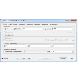
The topography module allows the importing of files from total stations and the most usual data collectors on the market. Data can also be entered manually in tachymeter, theodolite, distance meter or total station mode which can be defined by the user, selecting the horizontal or geometric distance, vertical angle or change in level etc.
Based on this information, the program provides all the tools required for the processing, calculation and drawing of stations and topographic points. Stations calculation can be carried out by radiation procedures, inverse bisection, direct and inverse intersections and levelling.
The program compensates the mean distances and slopes in the calculation of points and stations. Optionally, corrections may be considered by refraction and sphericity, reduction to ellipsoid and combined scale factor.
It also includes the automatic correction of disorientations of mutual observations and instrument angular errors in direct-inverse circle observations. Finally, for these calculations to be more precise, a table is included with the precisions and characteristics of the most usual instruments.
MDT includes the compensation of networks and traverses (closed, open and tied to one or more fixed points) by Least Squares, proportional to the distances, coordinates' increases, Crandall rule or rotation and dilation.
The program allows the configuration of admissible errors and for calculation methods which use Least Squares, the tests can be activated which assess the reliability of the observations and of the adjustment made.
The program includes the EPSG data base which incorporates hundreds of coordinates' systems and vertical and geodesic datum transformations from all around the world, including an adaptation to the Geocentric Reference System for the Americas (SIRGAS). This data is used by the mapping projections library PROJ.4 to carry out conversions of coordinates between the different systems. The coordinates' units may be meters, miles, American feet etc. The most usual systems can be selected from a list of favorites.
A powerful geodesic calculator allows the implementation of the most usual transformations and/or conversions between geographic, geocentric and projected systems.
Furthermore, this module includes options for converting projected coordinates' files into generic format X, Y, Z and geographic coordinates into KML formats from Google Earth, GPS exchange Format (GPX) and W84 from TcpGPS.
Finally, another command allows the projection of drawings opened in CAD, applying the transformations to the complete drawing, a list of layers or a selection of objects and being able to decide whether the elevations will be included in the calculations.
The selected transformation applies to all drawing entities (vertices of lines, arcs and polylines, text insertion points and blocks etc.).
It is also endowed with specific options for transforming a flat and projected coordinates' drawing and vice versa.
This module also has options for local coordinate systems application and management with the following methods being available:
- 2D: XY Translations, Helmert 4 parameters, Similar and Projective.
- 3D: XY Translations and Helmert 7 parameters.
- 2D+1D: Helmert 4 parameters + Z Displacement and Helmert 4 parameters + Z Displacement and Slopes at XY.
To create a local coordinate system there are various possibilities: enter the value of the transformation parameters directly (rotations, translations etc.), establish the pairs of source and target points involved or by importing a predefined file. The program generates a detailed report in which the parameters calculated, various statistics and the coordinates of the checkpoints involved are provided.
Once the local system has been created, recording can be carried out to subsequently carry out transformations of drawings and files of coordinates and it may also be used in the TcpGPS application for mobile devices.
Specifications
-
Data management
-
Security options for access
N
Search on file content
N
Version management
Y
Save standardization for drawings/maps
Spatial reference system
Selectable
-
Geometry types
-
Points
Point
Lines
Surfaces
Multipolygon
-
Other
-
License or freeware
License
Training
Y
Main users
Surveyors
Main applications
Coordinate transformation, total station calc.
Distinguishable features
It runs as a standard CAD application.Conversion of total station measurement files.Point and station calculation. Traverse and network compensation by least squares.Coordinate transformations.Transform from/to local systems.Geodesic calculator.Drawing transformations.
Related products
AutoCAD, BricsCAD, GStarCAD, ZWCAD
-
2D Editing
-
Select
Remove
Graphic transformations
Others
Coordinate transformations
EPSG database with ellipsoids, datum transformations, geographic, geocentric and projected coordinate reference systems.Geodesic calculator and conversion of point files and full drawings.Local systems: Helmert 2D (4 parameters), Affine (6 parameters), Projective (8 parameters), Helmert 2D+Verfical offset, Helmert 2D+Vertical offset and slopes, Helmert 3D (7 parameters)
-
2D Construction
-
Positioning by coördinates
Y
Positioning by snapping
Y
Positioning on virtual raster
N
Positioning in relation to other element
Positioning by Dimensions
Y
-
Storage
-
Type of data storage
File
Native storage format
dwg
Input formats
Others
Export formats
Others
GML version
None
Compression
N
-
Visualisation
-
Types
Change view
-
Data analysis
-
Merge
Map layers
Clip
Y
Measurement
Others
Topology
None
Tools to detect errors
Traverse and network least-squares adjustment report. Realiability and goodness of fit tests. Chi-square test
-
Interoperability
-
Web standards
Spatial database management systems
Messaging protocols
Extensions
-
General
-
Year of introduction
1997
Year of last update
2021
Supported hardware
Total stations, GNSS receivers
Supported operation system
Windows


