DatuBIM
Construction Data Analytics Platform
DatuBIM is an automated SaaS cloud platform designed and built for infrastructure construction projects. It enables you to monitor project progress, ensure quality, and control budgets based on actionable project execution metrics extracted from field data. By providing a single source of up-to-date data through the entire lifecycle of the asset built, DatuBIM empowers stakeholders to efficiently manage construction sites from planning through execution and maintenance.
Datumate
Yoqneam Ilit, IL
Description
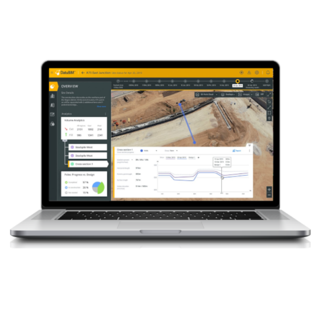
Optimize your construction projects with DatuBIM and data-driven insight
DatuBIM is an automated software-as-a-service (SaaS) cloud platform designed and built for infrastructure construction projects. It enables construction companies to monitor project progress, ensure quality, and control budgets based on actionable project execution metrics extracted from field data.
By providing a single source of up-to-date data through the entire lifecycle of the asset built, DatuBIM empowers stakeholders to efficiently manage construction sites from planning through execution and maintenance. Digitizing and automating monitoring, data analysis and reporting processes bring simplicity and collaboration for your project management.
DatuBIM 2.0 a non-intrusive, end-to-end service and collaboration platform that delivers automated engineering data analytics within hours of data capture. As-built digital twins and automated multi-dimensional, customized analytics deliver valuable insights for optimizing control and document processes, quality and budget. Built for speed, DatuBIM delivers automated engineering analytics within 24 hours, including automated comparisons with design plans, execution milestones and schedules.
Specifications
-
General
-
Year of initial introduction
2017
Year of last update
2019
Field of Use
Road Construction, Railways, Infrastructure Construction
-
Other
-
Support
Yes
Training
Y
-
Modelling and visualisation
-
3D model from 2D map extraction
Y
Point cloud modelling
Y
Automated modelling options from point clouds
Lines
Rendering and animation capabilities
3D image rendering
Material and texture capabilities
Yes
-
Planning and management
-
Cost Estimation
Yes
Phase planning
Yes
Schedule linking with other projects
Yes
Site analysis
Yes
Asset management
Yes
Maintenance scheduling
Yes
-
Analyses and simulation
-
Time series analysis and lifecycle data
Yes
Other analyses and reports
Progress, Quality, Volumes\Quantities, Completion to Design
-
Data, interoperability and data collection
-
Import and export formats [BIM]
DXF, DWG, LAS, OBJ, PDF, GEOTIFF, CSV
Import and export formats [General CAD]
DXF, DWG, LAS, OBJ, PDF, GEOTIFF, CSV
Compatibility with design systems
CAD
-
Functionalities
-
Cost estimation [Material quantities and costs are automatically extracted]
Yes
Construction simulation [Time and cost simulation and management]
Yes


