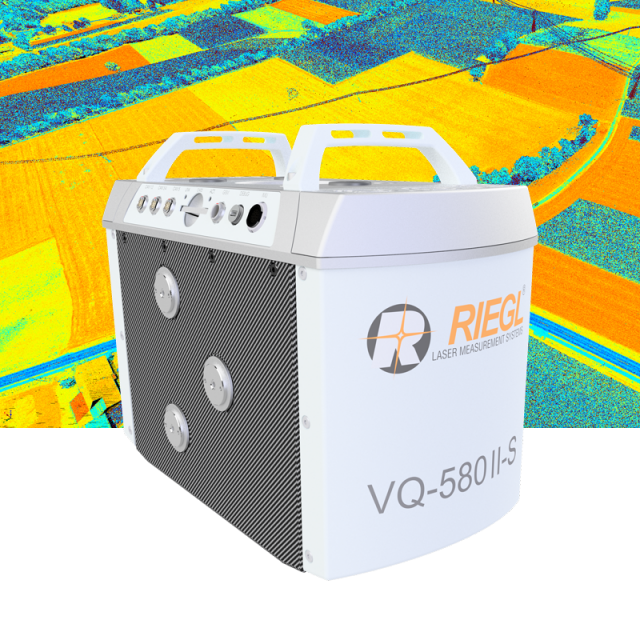
VQ-580II-S
Waveform Processing Airborne Laser Scanning System with Increased Range Capacity
To meet the increasing requirements of compact laser scanners for medium- and wide-area mapping as well as for corridor mapping, RIEGL now offers the VQ-580 II-S. The successor of the well-proven VQ-580 II Airborne Laser Scanner provides an increased maximum measurement range of up to 2.450 m.

RIEGL | Innovation in 3D
Horn, AT
Description
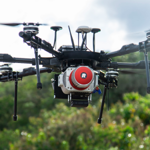
To meet the increasing requirements of compact laser scanners for medium- and wide-area mapping as well as for corridor mapping, RIEGL now offers the VQ-580 II-S. The successor of the well-proven VQ-580 II Airborne Laser Scanner provides an increased maximum measurement range of up to 2.450 m. It is perfectly suited for integration with gyro-stabilized mounts as well as into the VQX-1 Wing Pod, RIEGL’s fully integrated laser scanning system for user-friendly installation on Cessna single piston engine aircraft to facilitate various airborne mapping applications.
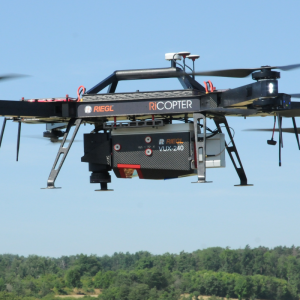
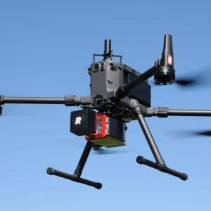
The device‘s lightweight and clean design allows seamless integration into stabilized platforms or even small hatches and enables the efficient acquisition of high-quality data for a variety of applications from a wide range of manned aircraft such as helicopters, small fixed-wing aircraft and ultralight aircraft.
Based on RIEGL‘s proven Waveform-LiDAR technology, the VQ-580 II-S provides highly accurate and precise point clouds, excellent vertical target resolution, calibrated reflectance readings, and pulse shape deviation for unsurpassed information content on every single measurement. With a measurement rate of up to 1,250,000 meals./sec and an extremely wide field of view of 75 degrees, the instrument is versatile and perfectly meets the challenges in various special airborne surveying applications like corridor mapping, city modelling, agriculture, and forestry. Due to the laser wavelength used, the system enables measurements to wet and frozen surfaces and delivers first-class results in snowfield mapping and glacier monitoring.
The RIEGL VQ-580I I-S provides mechanical and electrical interfaces for the integration with an appropriate IMU/GNSS unit and is ready for controlling up to 5 optional cameras. Convenient access to the acquired scan data is ensured by data storage on an easy to remove CFast® storage card and an integrated Solid State Disk, but also by streaming scan data via a LAN TCP/IP interface.
Do you have questions about this product?
- Questions about price, availability, and/or retailers
- Questions about technical specifications and usage
- Questions about suitability for your project or application
Specifications
-
General
-
Year of introduction
2022
Total Weight [kg]
10.5
Power requirements
18-34 V DC, 140 W
Type of GNSS/INS positioning system
optional
Camera
optional
Data storage facilities
Solid State Disc SSD, 2 TB; Cardholder for CFAST storage cards
Mission planning software
RiPARAMETER,IGI Plan; TrackAir; or similar
Postprocessing software
RiMTA ALS, RiACQUIRE, RiPROCESS, RiWORLD
-
Application
-
Main applications
Medium to Wide Area Mapping • Corridor Mapping • City Modeling • Glacier and Snowfield Monitoring • Agriculture & Forestry
-
Measurement Characteristics
-
Scanning method
rotating polygon mirror
Min. pulse frequency [Hz]
300000
Max. pulse frequency [Hz]
2000000
Max. field of view [deg]
78
Max. number of recorded echoes per pulse
15
Full-wave form digitization
Y
multiple pulses in air
Y
-
Operation Characteristics
-
Platform
Helicopter, Fixed-wing, Gyroplane
Min. flying height [m]
20
Max. flying height [m]
2450
-
Laser Pulse Characteristics
-
Beam divergence [mrad]
0.28
Type/class laser
3B
-
More information
-
Distinguishable features
increased measurement range of up to 2.450 m • high accuracy ranging based on RIEGL Waveform-LiDAR technology • high laser pulse repetition rate up to 2MHz • measurement rate up to 1,250,000 measurements/sec • perfectly linear and parallel scan lines • wide field of view of 75° • excellently suited to measure to snow & ice • interfaces for up to 5 optional cameras • mechanical and electrical interface for IMU/GNSS integration • removeable storage card and integrated Solid State Disk (SSD) for data storage • compact and lightweight design • compatible with stabilized platforms and even small hatches • seamless integration and compatibility with other RIEGL ALS systems and software packages
-
Application areas
-
Select an application area:
Documents
Brochure
datasheet_vq-580ii-s
Other documents
-
Applicationsheet Forestry & Agriculture.pdf3.41 MB
-
Infosheet ALS Overview.pdf4.34 MB
-
RiACQUIRE Datasheet.pdf4.34 MB


