Join 40,000+ geospatial professionals and get technology news delivered straight to your inbox every week. Subscribe today.

3D-RADAR Application Series: Pavement Analysis

Thu, Aug 20, 2020 at 11:00 AM (AST) 1 hour
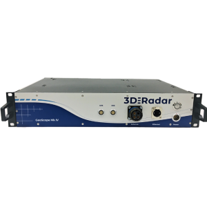
Mike Heitzman and Paul Collins continue the Application Series with a review of using 3D-RADAR technology to collect and analyze pavements.
3d-radar-logo-webinar-0.png
Share webinar

Mike Heitzman will examine how using 3D-RADAR to analyze pavements produces a full data set, allowing better understanding of the asset conditions and fully informed decisions on extending asset life. Paul Collins will use Examiner to extract layer thickness and volume, show areas of pavement distress, and quickly extract and report pavement features.

Ask a question

3D-RADAR team is happy to assist.

3D-RADAR

We're available on all weekdays and usually reply within 1-2 working days.

Please provide detailed information. Your input helps 3D-RADAR assist you effectively.

Let us know a little about you and your contact information.

Do you represent a company or organization?

Before we proceed, would you be interested in subscribing to our newsletter?

By completing this form, you acknowledge and agree to abide by our Terms and Conditions, Privacy Policy and Cookie Policy.

Thank you for your message! Our team tipically to respond to inquiries within 1-2 business days.